Search www.washingtoncountyks.net
| Attorney |
| Business Directory |
| Clerk |
| Commissioners |
| Communications & 911 |
| Community Services |
Travel & Tourism/Group ToursGloria J. Moore, Director
Your are cordially invited to visit Washington County, located in North Central Kansas on U. S. Highway 36. The Pony Express Hollenberg Station, a State Historic Site, is the only unaltered station remaining at its original location, looking much like it did in 1857. A great place for a stop along your journey. Washington County is primarily an agriculture area growing wheat, milo, corn, soybeans, alfalfa, and prairie hay. You will also find fields of sunflowers, the State Flower, grown within the County. Dairies and cow-calf herds can also be found throughout the 30 square mile boundary of the County. You will find the skyscrapers of the prairie, (grain elevators) dotting the horizon from corner to corner. Although agriculture is primary, you will also find manufacturing. Metal fabrication and machining, truck rebuilding, screen printing, construction, pallet building, livestock and bison handling equipment are included in the diverse mix. Soybean processing, honey extraction, and pet wholesaling also add to the diversity of the County. Washington County is made up of 12 Villages who welcome visitors to their communities. There are Community festivals and activities occurring monthly in the various Villages. You wont find one fast food franchise in our County, but you will find home-cooked meals at cozy little Country Cafes. We dont even have a stoplight in our County, however you can stroll through an antique shop or quilt shop bringing back memories of grandmas house. We look forward to becoming a day trip, rest stop, or destination on your route though the State. Plan an overnight stop or weekend visit. Antique shops, Museums, Home-Made Pies, Kansas Specialty Dog Service, and Church tours can be found to intrigue the visitor. We have a Buffalo Ranch and a Genealogy library to visit. A Music Festival, Wild West Show, Lighted Horse Parade, and Antique Tractor Show are a few of the events held during the year. Please contact the tourism office for more information regarding catered meals, restaurants, shopping, step-on guide services, and lodging in the area. The office also has information regarding outfitters and guide service for the hunter. Deer, pheasant, quail, and turkey are hunted throughout the County. The County has a State Fishing Lake, plus rivers, streams and ponds for the fisherman. (Refer to our Sportsmans Information) We maybe small in size, however we are great in spirit. Highlights of each Village have been listed in the following descriptions. You will find signs in each village that briefly describes their founding history. For more information please check out each Village listed, and also www.travelks.com before making your travel plans. Thank you in advance for considering Washington County in your travel plans.
Barnes ~
Clifton ~ Greenleaf
~ Haddam ~ Hanover ~
Hollenberg
|
|||||||||||||||||||||||||||||||||||||||||||||||||||||||||


 Berner Memorial Park 50+
Camping Hook-Ups, 2 ball fields, horseshoes, kiddy park, picnic
pavilions, swimming pool, and tennis court Berner Memorial Park 50+
Camping Hook-Ups, 2 ball fields, horseshoes, kiddy park, picnic
pavilions, swimming pool, and tennis court
|

|
|
|

Events:
-
May Alumni Celebration
-
July 4th of July Celebration
-
August County Music Festival and Wild West Show
-
October Halloween Parade
-
November Veterans Day Parade
Food, Lodging, & Specialty Shops:
-
Clifton Café
-
Sunflower Inn
-
Cottage Creations
-
LCL Buffalo Ranch & Meats
-
Kountry Trends
-
Petals N Pearls
Points of Interest:
-
Brantford Covenant Church Country
-
LCL Buffalo Ranch
-
Christian Church
-
What Not City
-
Faith United Presbyterian
-
Clifton Historical Museum
-
St. Marys Catholic
-
Berner Memorial Park
-
Old City Jail
-
Founders Sign
 Greenleaf is located 1 mile North of Kansas Highways 9 & 148 on Hwy 119 or 7 miles South of U. S. 36 on Country Road. Greenleaf was founded and laid out in 1876 by the Central Branch of the Union Pacific Railroad Company. Greenleaf was named after A. W. Greenleaf, treasurer of that company. The railroad reached Greenleaf in December 1876. Greenleaf was considered the end of the main line until its extension further in 1877. Greenleaf became incorporated on September 6, 1880, and the first election was held September 7, 1880. For more information phone 785-747-2858 or check the Kansas Travel site at www.travelks.com. |
|
|
The Sacred Heart Catholic Church is on the South edge of Greenleaf. The beautiful red brick Church is over 100 years old. Cornerstone laid 1899. |
|


Events:
- May Memorial Day Services
- June Fun Day
Food Specialty Shops:
-
American Legion
-
Elite Café
-
Twin Valley Thriftique
-
Lynes Unlimited Wooden Toys
Points of Interest:
-
Bethlehem Lutheran Country
-
1938 W.P.A. Clubhouse
-
St. Michaels Catholic Church Kimeo
-
Native Stone Jail
-
Trinity Lutheran
-
Greenleaf City Cemetery
-
Sacred Heart Catholic Catholic Cemetery
Haddam is located 3 miles North of U. S. Highway 36 on Kansas Hwy 22.
Haddam was founded in the fall of 1869 when J. W. Taylor built and stocked a small store on land donated by George Canfil. It was named by George after the town of Haddam, Connecticut. Near this time, A. Whitney opened a store on his claim, a short distance west, and started a rival town, which he also called Haddam. When Mr. Canfil resigned as postmaster, Mr. Whitney was appointed postmaster and the post office was moved to West Haddam. In 1874 Mr. Whitney sold his stock of goods to H. H. Cheney, who moved it to the present Haddam. For more information contact 785-778-3631, website: www.ci.haddam.ks.us, or Kansas Travel site www.travelks.com.
 The 1901 election saw an all
women City Council elected along with the Mayor, City Clerk, and
Police Judge, even though women were not given the right to vote
until 1920. Right away, the women decided to build a jail,
accepted a $325.00 bid and saw construction of the stone jail
within five months. The jail, on its original site, is one-half
block south of Haddams main street at the bank corner. The 1901 election saw an all
women City Council elected along with the Mayor, City Clerk, and
Police Judge, even though women were not given the right to vote
until 1920. Right away, the women decided to build a jail,
accepted a $325.00 bid and saw construction of the stone jail
within five months. The jail, on its original site, is one-half
block south of Haddams main street at the bank corner. |
|
|
|
 $2.50/day green fees. (Sand greens) Payable at the course. Phone 785-778-2425 for more information |

Events:
-
July Haddam Frontier Days
-
Oct. Lords Acre Day
Food & Specialty Shops:
-
Haddam Café
-
Grandma Bs Honey
Points of Interest:
-
United Methodist Church
-
1901 Jail
-
Church of God of Prophecy
-
Haddam City Hall
-
Griswold Wildlife Area
-
Haddam Golf Course
 Hanover is located 4 miles North of U. S. Highway 36 on Kansas 148, and ½ miles west on Kansas Hwy 243. Hanover was founded by Gerat Hollenberg in 1869, becoming incorporated in July 1874. Mr. Hollenberg was born in the German State of Hanover. Mr. Hollenberg established his Cottonwood Ranch just east of Hanover, which became a station where immigrant wagons, stagecoaches, and Pony Express riders all paused in passing along the Oregon-California and Pony Express Trails. The Western Brewery and Malt House, built in 1870, is a two-story brick building west of the Hanover Hospital. It operated for 10 years as a saloon brewery until State prohibition forced its closing. Information Phone 785-337-2242 or visit the Travel Kansas Site at www.travelks.com. |
|

|

The Hollenberg Pony Express Station, a State Historic Site, is
the only unaltered station remaining at its original location,
looking much as it did in 1857.
A visitors center is located west of the Station.
For information phone 785-337-2635 or hollenberg@kshs.org.
Located at
|
Events:
-
June Alumni Celebration
-
July 4th of July Celebration
-
August Days of 49
-
Pony Express Festival
Food & Specialty Shops:
-
Ricky Cafe
-
T's Restaurant
-
Wildcat Express
-
Pony Express Cafe
Points of Interest:
-
St. Johns Catholic Church
-
Hollenberg Pony Express Station
-
Zion Lutheran
-
Western Brewery & Malt House
-
St. Johns Lutheran
-
Pony Express Sculpture
-
Trinity Lutheran
-
City & Catholic Cemeteries
Hollenberg is located 8 miles North of U. S. Hwy 36 on Kansas Hwy 148 and 8 miles West via County Road. Hollenberg is the smallest village in Washington County.
Hollenberg was named after its founder Gerat Hollenberg in 1872. For years the City of Hollenberg was known for its community well, which is still located in the middle of the street in the downtown area. The water was available for residents to carry to their businesses or homes for personal use. For more information phone 785-337-2156 or visit the Kansas Travel site at www.travelks.com.
 The founding
history sign is located in the City Park. The founding
history sign is located in the City Park. |
|
 The Hollenberg
Post Office is the only active Business within the City
Limits.
The Hollenberg
Post Office is the only active Business within the City
Limits. Points of Interest:
-
Zion Lutheran Church
-
Community Well
| Linn is located on Kansas Highway 9. Planned in a boxcar in 1877, Linn was first named summit by surveyors, because it was at the highest point of the Missouri Pacific branch. The name was changed to Linn when the town applied for a post office. The name came from a physician and politician Lewis Fields Linn, who served as U. S. Senator from 1833 to 1843. Senator Linn was instrumental in the acquisition of the Oregon Territory for the United States. The first plat of the City was filed in 1883. For more information phone 785-348-5839, or visit the Kansas Travel site at www.travelks.com. | |

Stained Glass in the Chapel at
the Linn Community Nursing Home. |

Founding Sign located in the |
Events:
-
May Alumni & Memorial Day Activities
-
July Linn Picnic
Food & Specialty Shops:
-
Wholmoor American Legion
-
Peters Country Mart
-
Just Left
Points of Interest:
-
St. Pauls Lutheran Church
-
United Methodist Church
-
Zion Lutheran (Mo. Synod)
-
Immanuel Church
Mahaska is located 12 miles North of U. S. Highway 36 via County Road.
Mahaska was founded in 1887 by L. Bonham. Mahaska is the Indian version of the name White Cloud II, meaning White Swan. White Cloud II was a chief of the Prairie Sioux. Located one mile west and one mile north of Mahaska you will find the 1856 Surveyors Monument. Originally marked in 1856, this site was the beginning point for land surveys for all land in Kansas, Nebraska, three-fourths of Colorado, most of Wyoming and a small part of South Dakota. The original marker was discovered in 1976, and a new monument was dedicated in 1987. For more information phone 785-245-3368 or visit the Kansas Travel Site at www.travelks.com.
 The Sixth Principal Meridian or 40th Parallel Marker came about on May 30, 1854, as Congress agreed to establish and survey the Kansas and Nebraska territories. This surveyors point is the site from where more than 200 million miles of land was surveyed. |
|
 1940 W. P. A. Water Tower located in Mahaska City Park |
 One
cell City Jail located at the North End of Main Street. Door
is open for viewing. One
cell City Jail located at the North End of Main Street. Door
is open for viewing. |
Events:
-
July: 4th of July Celebration
Specialty:
-
Lambriar Kennels
Points of Interest:
-
Sixth Principal Meriden or 40th Parallel Marker
-
City Jail
-
1940 W. P. A. Water Tower
-
Community Center
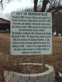
Morrowville is located 2 miles North of U. S. Highway 36 on Kansas Highway 15.
Founded in 1884, the town of Morrow was named for its founder, Cal Morrow, a state senator from 1876 to 1890, landowner and cattleman. The name Morrowville was chosen on June 7, 1884, because of confusion with the mail going to the Brown County town of Morrill. For more information phone 785-265-3155 or visit Kansas Travel site at www.travelks.com.
Founders Sign located |

In the
|
Events:
-
February Ground Hog Day Celebration
-
June Annual Whole Hog Barbeque
-
December Nanningas Christmas Joy land
Food:
-
Korner Café Jct. US 36 & Hwy 15
-
Morrowville Café & Bar
Points of Interest:
-
Cummings Park
-
Founders Sign
-
Christian Church
-
City Cemetery
-
St. Peter & Paul Catholic Country
-
United Methodist Church
Palmer is located 1 mile West of Kansas Highways 15 & 9 on Kansas Highway 115.
In 1879, a few buildings were moved from Petes Creek to a site two miles north next to the Union Pacific Railroad, Central Branch. E. A. Thomas laid out the town, naming it for J. Palmer, the first superintendent of public instruction in the County. The community of Palmer was actually founded in 1882, when a plat of the community was filed. Palmer will be celebrating its 125th year in 2003. For more information phone 785-692-4255 or visit the Kansas Travel site at www.travelks.com
 1920 Wooden Frame Jail Located East of Palmer Post Office Downtown Palmer |

|
|
|
|

Events:
- September Labor Day Celebration
Food:
- Palmer Café
Points of Interest:
-
St. Pauls Lutheran Church
-
Old Brown Hotel Laid Rock Outcropping
-
St. Johns Lutheran Church Country
-
1920 Jail
Vining is Located on Parallel Street, 1 block West of Kansas Highway 9, West of the Village of Clifton. Vining shares the same distinction as its neighboring Village of Clifton, since it lies in two counties. Washington County is on the North side and Clay County is on the South side of Parallel Street. Clifton and Vining each has their own City government, however they work together holding community events. The largest event being the Clifton/Vining Music Festival held in August. For more information phone 785-455-2229, or visit Kansas Travel site at www.travelks.com. Also, visit sister Village of Clifton.
 Marker at the site of the Vining Post Office in Operation from 1907-1954. |
 Entering
the City of
|
Events:
- August County Music Festival and Wild West Show
Food:
-
Bretts Club
Points of Interest:
-
Founders Sign
-
City Park
-
Refer to Information listed under Clifton City
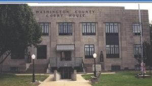
 Washington is located on U. S. Highway 36 and Kansas Highway 15. Washington is the County seat. Gold-seeks traveled by the thousands through Washington County in 1849 along the Oregon-California Trail on their way to California. Not until 1857 did the first settlers come in numbers to claim farms in the rich creek and river valleys. In 1860, one year before Kansas was a State, Mr.s Ballard, Bowen, and Pierce founded Washington. Following the Civil War, settlers came more rapidly and the town began to grow. The coming of the Union Pacific Railroad to the community was celebrated in 1877. The Burlington Northern arrived in 1884. The community was named after our First President, George Washington. For more information phone 785-325-2284, or visit www.washingtonks.net, or Kansas Travel site at www.travelks.com. |
|
|
|
1882
|
Events:
-
May June Swap Meet & Tractor Show
Jayhusker Races
Washington Speedway -
June Rodeo
Jayhusker Races
Washington Speedway -
July 4th of July Celebration
-
July-Aug. - County Fair
-
Dec. Santas Gifts & Goodies
Hearts N Things Bazaar & Auction Country Antiques
Food, Lodging, & Specialty Shops:
-
Longhorn Bar & Grill
-
Schookys Deli
-
Honeysuckle Fabrics & Quilts
-
Main Street Market
-
Swirley Top
-
Tre Barista
-
K-Motel
-
Seven Days Inn
-
Gas N Shop
-
Short Stop
-
Mar-Con Pies
-
Tea & Treasures
Points of Interest:
-
United Methodist Church
-
County Courthouse
-
Baptist Church
-
Washington County Historical Museum and Genealogy Library
-
St. Augustines Catholic Church
-
Church of the Brethren
-
1882 Log Cabin
-
Christian Church
-
Allis Chalmer Museum
-
Good Shepherd Lutheran
-
W.P.A. Limestone Buildings - Fairgrounds
-
Vision of Grace Independent Baptist
-
KSDS
-
Cedar Hills Golf Course
-
Munchkinland Playground at City Park
-
Tea & Treasures
Scenes Around the County
|
Washington County |
|
|
|

|
 Buffalo Herd near Clifton on LCL Buffalo Ranch |
 Dam over Mill Creek Southside of Washington City Park |

Kansas Specialty Dog Service, Inc.
|
 Annual Antique Tractor Show & Swap Meet Washington - June |
 Skyscrapers
of the Plains Or to us Locals The Grain Elevator.
Skyscrapers
of the Plains Or to us Locals The Grain Elevator.
Address:
214 C Street
Washington, KS 66968
Phone:
785-325-2116
Fax:
785-325-2830
E-mail:
washcott@
washingtonks.net